Sunday, March 22, 2015

A Message to the World

Dear Readers,

This a very worst issue of the world can be resolved.

We need to find & check the unused and not working tube wells to stop the "Intra-Bore Well Flow" of the water through the vertical holes of the tampered Groundwater Holding water proof rocks between the aquifers made by deep tube wells and has to prevent the unnatural flow of water from one aquifer to another than into the sea under the Ground. The improvements will be like:-

- That it may increase the availability of the water at higher levels in the active tube-wells.
- That it may increase the levels of the Groundwater.
- That it may improve the Dark Zones of the Groundwater Depleted Areas.
- That it may bring results of Rivers Connectivity Program, even if not implemented.
- That Shifting of seasons due to displacement of Center of Masses from Ground to sea has to be cured.
- That Shifting of Seasons may be due to angular variation of tilted axis or wobbling of the poles.

All these benefits can be achieved and we want to get involved practically, but due to lack of funds for our NGO and ignorance of the Governments it can't be possible and we have to take some strict measures around the world at the last stage of the environmental damages.

The God may give proper directions for the betterment of The Mother Earth.

Regards

Yashwant Deora
WhatsApp: +91 9352545652

Wednesday, April 21, 2010

Introduction


A Concept of 
Global Warming &
Groundwater Depletion


By
Yashwant Deora,
Jodhpur, Rajasthan,
INDIA
Released On: 28 Jan, 2010


Copyright © 2010-11 Certificate issued by
Ministry of Human Resource Development,
Government of India


Dear Readers,

       A Concept of "Groundwater Depletion and Global Warming" was already sent to the Government of India and State Government of Rajasthan. The Concept was forwarded by the Government of India to Ministry of Environment and Forest for further analysis. The Chief Minister of State has also sent this Concept to the experts of Groundwater for necessary comments.

     Many experts agreed after reading “Groundwater Depletion and Concept of Global Warming” that it is a common predicted phenomenon by our scientists that pumping of recharged groundwater is very less in comparison of water we are pumping out of from the wells and tube wells for irrigation, but we really missed to study or about to think that the immense water is also being continuously through intra-bore well flow for 24 hours from one aquifer to other through the vertical holes of billions of deeper multi-aquifer tube wells, which is much larger quantity than the water extracted by us for irrigation.

     Some experts also agreed that due to the holes in the impermeable layer an aquifer can’t be or act as an aquifer. We have created permeability between the two aquifers by deeper "multi-aquifer" tube wells or bore wells.

     The government policy for Rainwater Harvesting is of no use because that will never bring any kind of effective impact to raise the groundwater level, because the immense quantity of water that was held by the underground spaces between the contour of the impermeable plate from millions of years, had moved from its original place towards the low land area and then into the Sea.

       Due to this unnatural activity there may be a availability of water in abundance in the farthest Aquifers of the Low Land areas; when water flows through these bypasses holes made by the deeper 'multi-aquifer' tube wells. 

       According to our scientists the ‘Green House Effect’ is by the 30% of the solar radiation reflected back which is absorbed by the greenhouse gases, that emits the infrared radiation which is responsible for the Global Warming, whereas the 60-70% of direct radiations exposing on the earth surface is not estimated/calculated yet which is more dangerous for us in the absence of insufficient evoporation of water from ground and loss of forest land & vegetation due to Groundwater Depletion which was available a few decades back when our first impervious layer was safer.

        In short we do not have water to evaporate or to bring vaporization either from lost wetlands or from the vegetation due to keep our Earth Surface cool; as it happens with a difference of temperature of water in Clay Pot and Metallic Pot. There is a clear picture of the atrophy of our Planet Earth and must have a correlation between all of these factors. Our experts are also talking about the shifting of the poles of the Earth, but they don't know why. These factors are evident in the form of 'Rise in the Sea Water Level', 'Depletion of Groundwater', and 'Melting of Glaciers' due to 'Global Warming'.

        I hope your comments on this Concept of “Groundwater Depletion and Global warming”, so that we could open a new track of investigation more promptly to take action over the root causes for final solutions to combat with the crises for drinking water, because we do not have another Planet Earth to shift upon in the whole universe.

        We need a ‘Big Change’ because there is a situation of “Lost Chance or Last Chance” in front of us and it is now very easy to understand for us after reading “Concept of Global Warming”.

Tuesday, April 20, 2010

Concept of Global Warming


A Concept of 
Global Warming &
Groundwater Depletion


Predicted By
Yashwant Deora,
Jodhpur,Rajasthan,
INDIA
Released On: 28 Jan, 2010

In Reference of:-
  1. Groundwater level may falls due to deeper tube wells, piercing impermeable layers in comparison of immense pumping of water for irrigation.
  2. The potable water disappearing from unconfined aquifer resulting saline water when pumping from the deeper tube wells.
  3. The punctured huge water holding spaces under the ground are more responsible for the Rising of Sea Water Level than Melting of the Glaciers.
  4. There is a correlation between the Groundwater Depletion & Global Warming; results the vanishing of vegetation due to impact of solar radiation in the absence of humidity.
  5. A Global Ordinance is required to save our Planet Earth as soon as possible.
  6. Factors Responsible for Heavy Rainfall, 2010 all over the world & Heavy Snowfall. (New - Dec, 2010)

Contents:-

  1. Abstract.
  2. Introduction of Global Warming.
  3. Structure of Our Earth.
  4. Causes of Groundwater Depletion.
  5. Nature of Mobility of water in artesian well and tube well.
  6. Why do we need deeper tube wells?
  7. Reason for increase of saline underground water.
  8. Causes of Rise in the Sea Water Level.
  9. Correlation between Depletion of Groundwater and Global Warming.
  10. Consequences of minimized Pumping of Groundwater.
  11. Causes of Low Rainfall and Floods.
  12. The Greenhouse Effect.
  13. Results and Solutions.
{This Prediction could be refined on the basis of further analysis}


Abstract
            The whole matter on the Real Facts for Depletion of Groundwater & Global Warming presented below is on the basis of best of my knowledge acquired on the observation and study of the various related issues and established a correlation by putting all these consequences together occurring during the last few decades and try to make logical reasoning over the actual factors those are responsible for the Depletion of Ground Water & Global Warming together. The presentation regarding a serious matter of Depletion of Groundwater & Global Warming should be read as a single issue named as “Concept of Global Warming”.
           
            It is a very alarming situation that the Groundwater level is falling in the Northern India region, California and various part of the world. Groundwater levels in Punjab, Rajasthan, Haryana and Delhi are falling down one meter every year and this issue can lead to extensive socio-economic stresses for the region’s 114 million residents in North India. According to NASA report published in International Journal Nature, 109 cubic km of groundwater has been lost in just six years (2002-08) and this could be the India’s largest surface reservoir Upper Wain Ganga and Doubled than the government’s estimation. Report also says that from the August 2002 and October 2008, the region lost 109 cubic km of groundwater; almost triple the capacity of the largest man-made reservoir in the U.S, Lake Mead. This is a very serious issue which need to think more seriously as it could be the reason of collapse of agricultural output and severe shortages of potable water. Until 2020 many major cities of India is expected to experience a severe water crisis by per capita availability of water projected to be less than 1,000 cubic meters. Today there is a situation of “Lost Chance or Last Chance” in front of us and it is very difficult to understand for us.

            The Government of the many countries has implemented various groundwater protection policies and legislature for a control over the pumping of the water from the ground, like rain water harvesting from the roofs of the government and private buildings to collect the rainwater in the tanks and diverting the rainwater towards the opening of the wells for the replenishment of the aquifers below the ground; on which millions of rupees already been spending on various projects, that will be definitely proved as fruitless efforts. We are facing the alarming stage of the groundwater level is falling in various part of the world which assuming that is due to expansion of crop land area and immense pumping of the water for irrigation; it may be one of the reasons but, it may not a complete responsible factor for this alarming situation throughout the world. In this regard a study on various factors and issues was performed and a logical report is illustrated. What my assumptions are about the causes of the Depletion of the Groundwater and the Global Warming are given below:-

Monday, April 19, 2010

Global Warming

2. An Introduction
            Let us start with Depletion of Groundwater that will end on Global Warming. Currently, both GW-Factor (Ground Water Depletion and Global Warming) are considered as a separate issues. Our scientists have predicted the causes of the ‘Depletion of the Groundwater’ is due to the immense pumping of water for irrigation whereas Rise of the Sea Water Level is due to the Melting of the Glaciers; the melting of the Glaciers is due to the Global Warming. The ‘Global Warming' is due to the Greenhouse Gases separately 

           We didn’t yet consider as if there may be a correlation between these two factors and blamed the emissions only. The solutions suggested to prevent the Depletion of Groundwater are limited up to few option of artificial recharge for the groundwater only. Assuming the same, if we pause the pumping of the groundwater for several years; this is sure there will be no improvement in the groundwater level because the causes predicted yet and the effort being performed to prevent the Depletion of Groundwater are incomplete in itself. We have still not able to find the right track of investigation to find what actually wrong tasks had been carried out by us under the ground which is completely responsible for the disappearing of the underground water and causes of Global Warming. We have still not able to reach to analyze human activities which are unnatural and may be one of the serious causes of disappearing of the groundwater and the Global Warming together.

            On the basis of the illustration given below we will find that disappearing of the groundwater may not completely due to the only immense pumping for irrigation. Because human life on this Earth is from the centuries and many rivers are still flowing from the beginning till today without any end, on the surface of the Earth; we can imagine that how much an unlimited presence of water below the earth surface is there. There were also no unusual trends in rainfall. In fact, rainfall was slightly above normal for the period and the aquifers are replenishing every year. In these situations, it is unbelievable that the groundwater can be finished only by pumping through the bore wells; whereas the fact is that we are exploiting a few percent of unlimited groundwater present below the surface of the Earth.

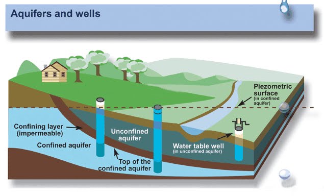
            It is a common predicted phenomenon by our scientists that pumping of recharge of the groundwater is very less in comparison of water we are pumping out of from the wells and tube well; but we have really missed to study or even we think that the immense water is also being continuously flowing for 24 hours downwards through the holes of the multi-aquifer tube wells from one aquifer to lower aquifer which is much larger quantity than the water extracted by us for irrigation. Some experts agreed that due to the holes in the impermeable layer an aquifer can’t remain or act as an aquifer. We have created permeability between the unconfined aquifer and confined aquifers by deeper multi-aquifer tube wells or bore wells.


            Due to this unnatural activity there may be a ‘New Released Pressure of Water’ in abundance in the farthest Confined Aquifers of the Low Land areas; when water flows through these bypasses/holes made by the deeper 'multi-aquifer' tube wells at the bottom of ‘large underground water reservoirs’ or impervious layer at the back of rises/heads of the impermeable layers towards the highland areas. Through these holes this ‘immense quantity’ of groundwater is flowing from one aquifer to another and then towards the sea, rising the Sea Water Level. It could be noted for the Jodhpur City that there is a rise in the Groundwater level, which may be due to immense pressure of water in confined aquifer below the impermeable layers, whereas there is groundwater depletion in the District areas only where there are numerous deeper tube wells and the example of new artesian wells discovered in Hanumangarh District and Jaiselmer District.

            According to the report of NASA more than 109 cubic km (26 cubic miles) of groundwater disappeared just in only six years which is only the consequence of the immense pumping of underground water? Is it possible that we could pump out 109 cubic km of water in six years, since 2002 to 2008? If not then where the water has gone? That much of amount of water was present before 2002; and the ratio analysis for the uses of water for irrigation and other drinking purposes cannot make such a big difference by the human activities between those six years and the last few decades. The Depletion of the Groundwater level and Global Warming was detected first time before few decades or a century in the History of the Earth. But, now we have to look under the hidden part of this problem which is also directly responsible for the Global Warming.

            We urgently need to study GW-Factor (Ground Water and Global Warming) those are adverse to each other. In few words we can say; Groundwater Depletion >> Escaping Humidity >> Vegetation Loss >> Global Warming >> More Vegetation loss >> More Global Warming >> Warm Winters >> Low Rabi Production >> Starvation >> Typical Human & Organism Life. On this Earth the Depletion of Groundwater is not only in Northern India, but it is also in other countries like Northern China, US, Algeria, Egypt, Pakistan, Iran, and Mexico etc. The Global Warming is directly related to the Depletion of Groundwater, and it occurs after the groundwater started pumping through aquitard piercing deeper tube wells since more that 30-50 years. Today, we are observing the effect of Global Warming on the vegetation, but we also need to observe the effect of Lack of Vegetation on Global Warming “conversely”.

Sunday, April 18, 2010

Our Earth

        Before we go for hydrological and GW-Factor analysis; lets us understand the structure of the Earth Crust and the real configuration of the existence of underground water between the aquifers.

       An aquifer is an underground layer of water-bearing permeable rock or unconsolidated materials (gravel, sand, silt, or clay) from which groundwater can be usefully extracted using water well. The study of water flow in aquifers and the characterization of aquifers; is called hydrogeology. Aquifers are underground layers of porous rock or sand that allows the movement of water between layers of non-porous rock (sandstone, gravel, or fractured limestone or granite). Many people tend to think of aquifers as “underground lakes” which is not the case because water is held between rock particles. Water infiltrates into the soil through pores, cracks, and other spaces until it reaches the zone of saturation where all of the spaces are filled with water (rather than air). The zone of saturation occurs because water infiltrating the soil reaches an impermeable layer of rocks so that it is not able to penetrate any further into the earth (this impermeable layer is known as an “aquitard” or “aquiclude”). Water held in aquifers is known as groundwater.

       The top of the zone of saturation is known as the water table. The water table typically follows the form of the above ground topography. The depth of the water table is typically greater in regions with low rainfall than in regions with high rainfall. The water table can rise in wet years and fall in dry years.

       In the figure-1 given below unconfined aquifer and confined aquifers are shown. Between any two aquifers a confining bed is running which is marked as impermeable rock layer which prevents the flow of water from one aquifer to another. In this pattern there are many aquifers between the confining beds holding unlimited underground water source, which was exploited by human civilization only by digging the wells from the upper unconfined aquifers from the centuries. The impermeable rock layer consists of layer with different rock properties. Many impervious layers may also known as aquitards which do not completely act as impervious layer but may allow some quantity of the water through it with low hydraulic conductivity. The thickness of the impermeable layer is not justified as it may be from couple of meters to several hundreds of feet.

       One more factor is considerable for the impervious layers that they are in the form of waves with up and down structure have very large storage of water between the two rises/heads of the impermeable layers. Every rises/head of the impermeable layers that may be several miles wider could sustain the water towards the high lands. These rises of the impermeable layers are responsible for the water table.

Figure-1  
          A few decades back in India and other developing countries we had only the option of "digging wells" for water exploitation, that time we don’t have tube wells drilling machines. The human civilization was able to reach only the depth of 100-200 feet by 'digging wells' to exploit water for drinking and agriculture purposes from the upper unconfined aquifer of the surface of the earth, which was the largest source of potable water collected by percolation of the rain water.

          In the upper unconfined aquifer the percolation is also continuous from the rivers basin flowing on the surface of the earth from centuries. We can say the recharge is still going on throughout the year from the rivers when there is no rainfall in the area. We are still exploiting a percent of water for drinking and irrigation purposes from the unlimited storage of groundwater. The Depletion of Groundwater due to ‘immense pumping’ may be incomplete prediction. Logically, it can be proved again that the downfall of groundwater level is still not due to immense pumping for irrigation ‘completely’ by considering the following illustrations: -

          Our scientists already mentioned that the groundwater is always recharging by the percolation of rain water into the soil from the various recharge area as potable water in unconfined aquifer. The rain occurs for few weeks in a year only; only 10-15% of water absorbed by the soil rest of it flows towards the sea and gets evaporated, whereas the groundwater is pumping out of the tube wells for irrigating the crops for 365 days; and a sufficient water must also goes under percolation, which should be collecting in the unconfined aquifer, with already percolated river and rainwater. Logically when a few percentage of rain water could percolate into the soil could bring the impact of rise in groundwater level then why the 365 days tube well used for irrigation water does not bring the rise in groundwater? Where that amount of water goes, which can result the Depletion of the Ground Water? Evaporates away, absorbed by the crop; how much? 

           Let us see the possibility of quantitative evaporating of the groundwater used for irrigation pumped from the tube wells. The maximum groundwater is pumped out during the winter seasons for the irrigation of Rabi Crops. We have seen that the rate of evaporation depends on the rise in the temperature of the surface which is directly exposing to the solar radiation or sunlight. In the crop lands, the land area is covered with the various types of crops preventing the solar radiation or sunlight to touch the ground, decreases the rate of evaporation of water into the atmosphere under the roots of the plants. When we had upper water table due to safer impermeable layer a few decades back, we had lot of humidity in the atmosphere due to ‘controlled’ evaporation of water from the vegetation and forest land.

         We also need to estimate for the quantity of rainwater absorbed by the plants and evaporates into the atmosphere in vast open land area in comparison to the percolating groundwater under the roots/cool shadow of the crops. The summers are exception due to dry atmosphere but, combat with the Global Warming we essentially need the water for evaporation to keep our earth cool. Today, due to Groundwater Depletion we do not have upper level of groundwater to create humidity due to evaporation.

         The best examples to understand the concept is the temperature of water in a clay-pot and in a metallic-pot. The temperature of water in the clay-pot decreases when there is an expansion of the water molecules in the form of water vapor, when evaporation of water take place, whereas maximum heat enters into a metallic pot in the absence of water evaporation.

         In the same way due to Depletion of Groundwater the upper surface loses the upper water table which was responsible for the humidity with the development of new vegetation and forest land which brings a controlled and balanced evaporation of water between the solar radiation and the earth surface. Currently we do not have evaporation in most of the areas where the groundwater level had reached several feet below the earth surface. In the absence of evaporation our Earth act as metallic-pot; the heat enters its surface up to maximum depth. Where there is humidity in the soil and vegetation/forestry due to higher water level, the Earth act as a clay-pot. We can imagine a situation of the environment and the temperature of our Earth after “few years” when we do not have groundwater at higher levels, because the same principal is applicable for the earth as well for the water in a clay pot and a metallic pot.

        In the past we had forest vegetation in abundance holding immense water in it and moisture in the soil that we are losing today because of drastic fall in the groundwater level, which is due to millions of deeper holes in impermeable layer. We also have to analyze that how much evaporation of water is there from the area of 5 sq. km. of the sea surface and the land surface under the same weather conditions. Hopefully, we will find too much evaporation of water from the land area in comparison of the sea surface that is very essential for cloud formation.

         Hence, due to Depletion of Groundwater we do not have water to evaporate. A percentage of immense water being pumping from the tube well goes under percolation after we irrigate for crops. The amount of water used for irrigation currently, is much less than the presence of water in the form of humidity in the upper earth surface, vegetation in abundance holding water and surrounding moisture and higher water table in unconfined aquifers before more than a Century; and we had lot of water evaporation also that brings cooling for the Earth Surface. We can still try to find the possibility to improve the Groundwater Depletion and could balance the water evaporation from the surface of the earth to control the Global Warming.

Saturday, April 17, 2010

Groundwater Depletion

            From the last few decades we are using the Drill Machines to drill tube wells anywhere, up to more than a required depth for groundwater exploitation. Due to uncontrolled deep drilling of the ground the first confining bed/aquitard/impermeable rock layers got damaged or punctured consequently the unlimited potable water is continuously flowing from unconfined aquifer to the lower confined aquifers and lower aquifer to upper aquifers thorough the millions of multi-aquifer holes made in the impermeable hard rock by the drill machines; resulting sudden rise in Groundwater Level in low land areas, whereas there is Groundwater Depletion in other high land areas.

        According to our scientists the depletion of the groundwater is due to water being pumped and consumed by human activities -- principally to irrigate cropland -- faster than the aquifers can be replenished by natural processes. Due to immense pumping for irrigation the groundwater depleting; then from where the excessive water is coming into the Sea raising it water level? We are lacking a study of common sense and saying that Sea water level is increasing due to melting of the Glaciers but there is still a question that how the water released from the glaciers reaches the Sea? If it is through the various aquifer channels then why there is a groundwater depleting? We really missed something and today nobody has studied yet about the direction of mobility of water when the impermeable layers are being punctured by the deeper tube well holes. According to the NASA: -

NASA Reported Ground Water level going down in North India

Beneath northern India’s irrigated fields of wheat, rice, and barley ... beneath its densely populated cities of Jaipur and New Delhi, the groundwater has been disappearing. Halfway around the world, hydrologists, including Matt Rodell of NASA, have been hunting for it.

According to Rodell and colleagues of NASA, it is being pumped and consumed by human activities -- principally to irrigate cropland -- faster than the aquifers can be replenished by natural processes.

"If measures are not taken to ensure sustainable groundwater usage, consequences for the 114 million residents of the region may include a collapse of agricultural output and severe shortages of potable water," said Rodell, who is based at NASA’s Goddard Space Flight Center in Greenbelt, Md.

Rodell and colleagues team analyzed six years of monthly GRACE gravity data for northern India to produce a time series of water storage changes beneath the region’s land surface. They found that groundwater levels have been declining by an average of one meter every three years (one foot per year). More than 109 cubic km (26 cubic miles) of groundwater disappeared between 2002 and 2008 -- double the capacity of India's largest surface water reservoir, the Upper Waingangā, and triple that of Lake Mead, the largest man-made reservoir in the United States.

"We don’t know the absolute volume of water in the Northern Indian aquifers, but GRACE provides strong evidence that current rates of water extraction are not sustainable," said Rodell. "The region has become dependent on irrigation to maximize agricultural productivity, so we could be looking at more than a water crisis" Said Rodell.

The loss is particularly alarming because it occurred when there were no unusual trends in rainfall. In fact, rainfall was slightly above normal for the period.


Figure 2

           According to the figure-2 the bottom of Tube Well is always opening in the confined aquifers instead of unconfined aquifer. We are exploiting the groundwater through the multi-aquifer tube well from the confined aquifers base for few hours in 24 hours a day, whereas due to millions of holes in the confining impermeable layers the potable water in the upper aquifers is also passing down continuously, which is many times than the water is pumped by the human for irrigation, resulting the water is also disappearing from the other wells of lower depth. Before the evolution of the drill machines; the water in the rivers and unconfined aquifer was moving towards the sea in the same upper structure of unconfined aquifer whereas, now the water from upper aquifers is flowing towards the sea after passing through the lower saline water confined aquifers. Water percolates in the unconfined aquifers from the river basin also passing down from the first coming holes of the tube wells which go into the sea via saline confined aquifers, results the Rise in the Sea Water Level.

           According to our scientists, the groundwater level falls due to a cone of depression created around the wells when there is a pumping of water from an tube well, which is correct, but it is also true that the cone of depression goes on increasing gradually due continuously passing of water from upper aquifers to the lower aquifers through the holes of tube well through the impermeable layers. The upper unconfined aquifer is a type of radiator for the Earth surface and the water disappeared from the unconfined aquifer acted as a coolant for our Earth’s Engine.
Figure-3 

          Let us assume a situation. It is well proof that the water pumping from the tube wells is from the saline water base; that is from confined aquifers below the impermeable layers. Assume for a while that water do not pass down through the holes in the impermeable layers made by multi-aquifer tube wells, then the percolated groundwater after irrigation should have collecting in the upper unconfined aquifer resulting lot of humidity and wetland with vegetation in abundance and then there would be no question of Global Warming due to humidity in the soil.

Friday, April 16, 2010

Intra-Bore Well Flow of Groundwater

An artesian well allows water that has traveled through porous rock from a higher elevation to rise towards the surface. This pump less well seems to defy gravity because the pressure that builds up between layers of rock gets relieved when the water finds a path to the open air. For nearly a thousand years, people have drilled wells to drink this cold, filtered water that doesn't need to be hauled up from the depths.

Two main forces drive the movement of groundwater. First water moves from higher elevations to lower elevation due to the effect of gravity. Second, water moves from areas of higher pressure to areas of lower pressure. Together these two forces make up the driving force behind moving groundwater which is known as the hydraulic head.

Water has the potential to move through four different types of rocks: unconsolidated rock, porous sedimentary rocks, porous volcanic rocks, and fractured rocks. In unconsolidated materials, the particles are not attached to each other in a coherent way (e.g., sand would be unconsolidated but sandstone would be consolidated). Water is able to move through the spaces between particles. Gravel and sand aquifers are common. Because there are more spaces between particles when particles are larger, water moves more quickly through layers of large particles (e.g., gravel) than it does through layers of small particles (e.g., clay).

Carbonate rocks, such as limestone, are brittle so they tend to fracture and these fractures allow some water movement. More importantly, because water will dissolve carbonate rocks once water is able to enter the fractures, the openings in the rock become larger allowing more water movement. Limestone rocks that have large dissolved openings in them are known as karst.

Artesian well is a deep drilled well through which water is forced upward under pressure. The water in an artesian well flows from an aquifer, which is a layer of very porous rock or sediment, usually sandstone, capable of holding and transmitting large quantities of water. The geologic conditions necessary for an artesian well are an inclined aquifer sandwiched between impervious rock layers above and below that trap water in it. Water enters the exposed edge of the aquifer at a high elevation and percolates downward through interconnected pore spaces. The water held in these spaces is under pressure because of the weight of water in the portion of the aquifer above it. If a well is drilled from the land surface through the overlying impervious layer into the aquifer, this pressure will cause the water to rise in the well. In areas where the slope of the aquifer is great enough, pressure will drive the water above ground level in a spectacular, permanent fountain. Artesian springs can occur in similar fashion where faults or cracks in the overlying impervious layer allow water to flow upward. Water from an artesian well or spring is usually cold and free of organic contaminants, making it desirable for drinking.

Factual Scenario: - A study was initiated in western Rajasthan, covering 13 districts, under a memorandum of understanding signed with Water and Power Consultancy Services (India) Limited, or WAPCOS, to identify broad areas for deeper groundwater exploration. Similarly, deep-seated fresh groundwater under artesian conditions was discovered in the Thar Desert in Pakistan in a village called Jumman Samoo, about 75 km east of Umerkot city. A 12-inch bore encountered an aquifer between 1,000 feet (300 m) and 1,200 ft (360 m). The well produced 200 gallons (378L) a minute, making water available without any operational costs.

In a Demonstration of ONGC Project Saraswati the villagers could not believe their eyes when clear water gushed out from a pump in the Thar Desert, 6 km from Jaisalmer in Rajasthan. The well, dug up to 400 metres, produced 76,000 litres of water an hour during a pumping test. Rajagopala Rao said a preliminary study had identified Jaisalmer, Bikaner, Barmer, Ganganagar, Nagaur and Hanumangarh districts for detailed investigation.

Now, let us have a look over the dark zones in India also. Punjab Agricultural University estimates had indicated that at least 100 blocks, out of 141, in the central districts of Kapurthala, Jalandhar, Ludhiana, Patiala, Sangrur and Moga had been declared dark zones. A report on “Dynamic Groundwater Resources of Punjab” prepared by the Water Resources and Environment Directorate of the state Irrigation Department and the Central Groundwater Board points out that “the number of shallow tube wells in the state has increased from approximately 50,000 in the 1960s to more than 11,70,000 in 2005. According to a Central Ground Water Board (CGWB) study, groundwater levels have gone down by more than four meters in 306 districts of 20 states over the past 20 years.

State                           Water level decline
Uttar Pradesh                42 districts
Madhya Pradesh             37 districts
Rajasthan                     30 districts
Maharashtra                  27 districts
Orissa                           24 districts
Tamil Nadu                    22 districts
Andhra Pradesh              21 districts
Karnataka                     20 districts
Gujarat                         18 districts
Haryana                       12 districts

           Coming back, to illustrate the nature of the flow of water in artesian well and tube wells by assuming the configuration of the aquifers below the earth surface as given in the figure 4. As stated above; for an artesian well, an inclined aquifer sandwiched between impervious rock layers above and below that trap water in it is necessary; this type of geologic condition is possible only by deeper penetration into the earth crust piercing the impermeable layers up to the depth of more than 300-400 meters. It is well known that the water held in these spaces is under pressure because of the ‘weight of water’ in the portion of the aquifer above it enters the exposed edge of the aquifer at a high elevation and percolates downward through interconnected pore spaces, which can be more than 200 gallons a minute, making water available without any operational costs.

Figure-4

This can be understood well by the illustration given below in the diagram which shows the length of the aquifers could be from few hundred of meters to several miles below the ground. We assume a section structure of the confined aquifers through which we have created the permeability by millions of holes in them. We see that due to holes in the confined aquifer below the land area C water flows down through the hole into another unconfined aquifer that further continuous under the low land area B. Here, we discovered that there is a depletion of groundwater under C whereas there is a drastic rise in the groundwater under the area of B. The multi-aquifer tube wells made in the area B brings further impact of the rise of groundwater under the low land area under A, where we find many artesian wells. We can finally say that deeper multi-aquifer tube well in high land area creates pressure in the confined aquifers under the low land area. The age of the artesian well will be longer till some more deep multi-aquifer tube wells would make bypass holes into the next confined aquifer and there will be a continuous fall of the groundwater in the high land areas.

It can be further illustrated that the fresh potable water receiving in the artesian condition in some areas like Umerkot city, central district of Punjab and Hanumangarh and Jaiselmer District of Rajasthan can be the source of water from the large underground water spaces located in the upper aquifers of the farthest “high lands”. The study of various scientific theories of our experts declared that as we go deeper for the groundwater, the salinity of water increases and it is the well proof concept.


Reply of Groundwater Experts under RTI Application


Thursday, April 15, 2010

Why do we need deeper tube wells?

           The wells dug by the man are wider and lower in the depth. Such types of wells have a big water storage space at the bottom and the water level goes on rising depending upon the pressure in the veins of the aquifers which is collected at the bottom from all the nine direction. But in a tube well the width is not more than 12-18 inches and there is not enough space to collect the water after released from the ‘few’ veins of the aquifers at the same depth, where the pumping may be the event of few minutes. For continuous pumping water, more depth of tube well is required that may be more than 500 to 1000 feet, to get the water from the 10th direction from the numerous veins in more than one aquifer (upper unconfined and confined layers) in the vertical column on the water pump.

Figure-5

             So, the continuous pumping of water is not possible from the tube wells at the same depth of the open wells in the same area; that is why we require deeper tube wells. Here we have bored the confining impermeable layer which is an unnatural activity; due to which the huge unlimited potable water in the huge underground storage in the unconfined aquifers passing down through the numerous 18 inched holes in the confining impermeable layer, due to which we are facing perilous result of Depletion of Groundwater, falls by 1 meters every year. Today, we are saying “Limited Water Resources” to “Unlimited Water Resources” because the recharge of ground water always going on by the rivers basins and the rainfall every year, which is an unlimited process till the End of the Earth.

Wednesday, April 14, 2010

Increase of saline underground water

           The water flowing in the unconfined aquifer is high quality potable water, which is collected by the percolation of the rain water and the rivers flowing on the earth surface. Whereas water flowing in the confined aquifer is saline due to solubility of the rock salt contains high concentration of iron, hydrogen sulphide or fluoride. The potable water in the unconfined aquifer goes on flowing down through the tube wells piercing impermeable layer and mixed with the saline water in the confined aquifers.

 Figure-6

           According to the figure 6 the bottoms of the tube well opens in the confined aquifers instead of unconfined aquifers or we can say that water is always pumping out of a tube well from saline water base. In that situation we are getting a mixture of potable water flowing downwards from unconfined to confined aquifers on the pump set and saline water. In the beginning we get suitable water; less saline for drinking purposes as well for irrigation till the supply of potable water from the upper unconfined aquifers continuous, but as soon as it finishes the concentration of the salinity increases due to the presence of mineral salt in the confined aquifers. We have made a uniform combination of water in the upper unconfined aquifers and lower confined aquifer by drilling vertical holes in the horizontal impermeable rock layer, as the consequences of it the potable water flows towards the sea by following the man made shortcut routes in the impermeable layer between the aquifers. Today we are facing the serious problem of the availability of drinking water and every creature including the human being has to drink the water highly concentrated with fluoride and other harmful rock salt which is responsible for the severe incurable physical deformities in their body.


Tuesday, April 13, 2010

Causes of Rise in the Sea Water Level

            Many scientists have predicted by their research over the present condition that the glaciers are melting due to the global warming, which causes the Rise in the Sea Water Level, consequently many islands like Tebua Tarawa and Abanuea Island are already disappeared from the map of the world. The Rise in the Sea Water Level, due to the melting of the glaciers may be one of the reasons but there are still other factors also which are more responsible for the Rise in the Sea Water Level which is not yet studied, highlighted or exposed till today. If we go deeper for micro research; in that regard we will discover few more factors which reveals that the basic cause of the rise in the Sea Water Level. We should also remember that Glaciers do not melt during the winter seasons, whereas the water is continuously flowing down through the holes of the tube wells towards the sea throughout the year.

            In the above described facts there is confining impermeable layer between the aquifers. These impermeable layers are running thickness in up and down waves patterns instead of pure horizontal plates which stores water in there deeper laps. The rising parts of these confining layers were responsible for maintaining a water table in the upper unconfined aquifer.  There are millions of such issues and situations naturally built between the unconfined and confined aquifers under the ground of the earth surface those may contain millions of cubic kilometers “Stable Water”. Some water storages are very ancient and many have incoming water from one side and going out from either side. We have made millions of drilling holes in the bottom of such huge water storage over impermeable layer, beneath the earth surface consequently the huge water holding spaces/pots are punctured to create an alarming water crisis to such a large extend that the body of the earth fails to hold the water in itself which is flowing freely towards the sea through the shortcuts made by us, resulting the major cause of Rising of Sea Water Level. Hence, the steps taken by the Government of India in the direction for the remedy of the falling groundwater problem are still incomplete and will be fruitless.

 Figure-7

           One more thing about the melting of the glaciers is still to understand for us. We have Glaciers in Asia are the glaciers of China, India, Pakistan, Nepal, and Tajikistan. Glaciers in Europe are the glaciers of Iceland, Norway, and Switzerland. Glaciers in South America are the glaciers of Argentina, Chile, Columbia, Peru, and Ecuador. Glaciers in North America are the glaciers of United States, Canada, Greenland and Mexico and the Glaciers of the New Zealand. These glaciers are melting due to the Global Warming, consequently there is a Rising in Sea Water Level as we have predicted till now.

           Now, let us compare the volume of glaciers (surface area & thickness) which is measureable; and the presence of very large volume of water in the aquifers in the uncertain height of the column below the total land area of the Earth Surface which is invisible and immeasurable. Obviously, the volume of the water released from the glaciers is much less than the water present below the earth surface. Let us have a look over the path of the water released from the melting glaciers towards the sea. The water released from the glaciers follows the path of the rivers and mostly percolated into the soil from the land area and the basin of the rivers and must get feeds up in the upper unconfined aquifer first. Due to melting of the glaciers, if the Sea Water Level could rise, then why the aquifer below the ground remains empty and the groundwater level is falling?

           We have predicted so far that due to immense pumping there is a Depletion of the Groundwater whereas, the situation must be opposite to it and we should have higher water table in the upper aquifers than before we had and the water level in the unconfined aquifers cannot be lowered; in the situation there are no holes in the impermeable layer; only by the immense pumping of the water for irrigation. The factual thing may be that the water present in unconfined and confined aquifers in a very large in quantity than the water released from the glaciers had lost underground holding places or aquifers and passes downwards through the tube well holes toward the sea. The water released from the glaciers also moves towards the sea through the lowest confined aquifers after passing through the first coming numerous holes in the impermeable layers instead of flowing through the upper aquifers.

         As predicted so far, that water from the melting glaciers raising the sea water level. We should also imagine a situation that if don’t have holes in the impermeable layers and the glaciers started melting “due some other reasons”. In that situation we must have our aquifers fully loaded with water and we can’t pump out that much of underground water that may results Depletion of Groundwater and serious drinking water crises when we have safe confining layers with no holes because the water from the glaciers will flow in the upper unconfined layers mostly.

Monday, April 12, 2010

A Correlation - Groundwater and Global Warming

     The final dangerous situation arises by our mistake needed a very serious investigation. A Climate Change Conference was held in Copenhagen where the representative and experts of from 170 countries participated to prevent global warming and climate changes. The conference was centralized only on the carbon emission issues and was failed due to weak consensus on the reason for Global Warming.  But the ground reality is something else, which is more responsible for the Global Warming; was not understood yet. Now, we need to see the Global Warming with a different angle, by keeping all the unnatural events together and then only we could able to see the factual image of the Global Problem.

     . Water exploited to irrigate larger crop land by a single tube well, require more depth and heavy power load pumping set. To acquire that amount of water we started reaching at the depth of more than 1000 feet piercing multiple impermeable rock layers. Consequently, the water started flowing down from upper aquifer to lower aquifers illustrated as above, resulting Depletion of the Groundwater. Due to fall in groundwater the earth surface is lacking humidity and our Earth is losing its cooling properties in the unconfined radiators. We need more illustration and investigation on this dangerous situation that will not be less dreadful in the coming next years

     We did not have drill machines to make tube wells a few decades back to exploit groundwater in an uncontrolled manner. That time our Earth’s confining/impermeable layer was safe and the groundwater level was maintained naturally at sufficient depth so that the roots of vegetation may grow in abundance on the earth surface. Unfortunately, we have adopted those unnatural tasks which make the groundwater out of reach of the roots of vegetation. The dense forests becoming dry; catches fire due to the absence of humidity and high temperature, our earth surface is also gradually converting into the desert land with the death of the organisms. The humidity is very necessary coolant factor which is losing with the fall of groundwater, could save our earth from the Global Warming.

     Few decades back when groundwater level was high we have vegetation was in abundance. A small uncovered area of the earth surface was exposed to the direct solar radiation as compare to current situation we have and the temperature of the earth surface cannot reach more than 5-8 meters in the depth. One night was more than enough for the earth to cool down and ready to absorb the solar radiation from the next day morning. Now, we have made such bad conditions for our Planet Earth that the groundwater level is falling 1-2 meter every year and the larger area of the earth surface lacking vegetation is exposed to the direct radiation and converting into the desert which increases the temperature in depth to an extent. One night is not enough for our earth cool down completely, retaining the temperature of the previous day in its upper crust till the sunrise of the next day and start heating again.

     According to the Second Law of Thermodynamics the temperature of the previous day retained in the upper Earth Crust travels towards the cold reservoir till it reaches the thermal equilibrium. The process goes on day by day with the rapid fall of the groundwater and the temperature of the earth goes on increasing by 1.4 degrees Fahrenheit every year resulting the melting of the glaciers due to which there is a Rise in the Sea water Level. Hence, the complete above illustration may define as basic cause of Global Warming. The rate of GW-Factor will be much higher in the next coming years because the people already started boring more tube wells in different areas in search of water up to an extent of a depth, till they reach the ground water.

Sunday, April 11, 2010

Minimized Pumping of Groundwater

     The cause of the Groundwater Depletion was predicted by as it was due to the immense pumping of groundwater for the irrigation purposes and it was confirmed by our scientists. What may be the possible emergency steps to control the depletion of the groundwater? Nothing, except artificial replenishment of the groundwater by rainwater harvesting, permission for digging wells, limited pumping, imposing cost on the water or an impossible complete pause on groundwater exploitation currently. 

     If the causes of the Depletion of Groundwater predicted in above point (3) are correct and, if we do not pump underground water for several years; this is sure there will be no improvement in the groundwater level due to holes in the impermeable layer. The policy for rainwater harvesting by the government may not bring any result for recharging of the groundwater because the immense water already being held by the spaces above the impermeable rock layers are losing its huge content of groundwater flowing through the shortcut may by the multi-aquifer tube wells towards the lower land areas and then into the sea.

     Now, let us assume a situation that there is complete pause over the groundwater pumping for irrigation purposes to prevent the Depletion of the Groundwater, irrespective of the question arises that what we eat if we don’t grow the crops for a while? No problem, suppose our scientists have arranged a new Crop Land on another planet, and our daily requirements for food are fulfilled from there.

     Consequently, in the absence of Crop Land we do not have humidity in the upper layer of the earth surface, which is created by agricultural purposes; consequently we will definitely face severe Global Warming Effects increased by 5-10 percent in the temperature of the Earth Surface, by the 70% of the solar radiation, is exposing the Earth Surface in the absence of humidity that were created by the Crop Lands. The immense heat generated will bring more adverse and dangerous effect by the increment of GW-Factor at higher rates. We should not forget the Water Cooler through which we evaporates the water vapor to keep a confined area cool around us and the clay pot in from which we drink cool water which is due evaporation of water from the holes of the pot. For that pot and our earth the sun is the same object.

     Today, the agricultural surface area and remaining vegetation around the world is working as a lifeline to maintain the humidity on the earth surface, which is acting as ventilator for us and for the Earth itself. It is unrevealed efforts performed by us by growing crops to keep the Earth cool due to somewhat by bringing humidity and water vaporization by the means of agricultural purposes in most of the parts of the world and we are doing undeclared activity to fill up the gap between the humidity and the Depleted Groundwater Level through the empty aquifers under the Earth Surface.

     According to our scientists the ‘Green House Effect‘ is by the 30% of the solar radiation reflected back towards the space and the heat absorbed by the greenhouse gases, emit the infrared radiation which is responsible for the Global Warming, whereas the 60-70% of direct radiations on the earth surface was not estimated/calculated till today which is more dangerous for us in the absence of humidity due to groundwater depletion and loss of vegetation, which was available due to a few decades back when our first impervious layer was safe. The GW-Factor was born firstly from the countries where the drilling hole for groundwater exploitation was started at largest level.

     Now, the meaning of pumping of groundwater should becomes to bring back the humidity in the large possible areas through the Crop Land irrespective of agricultural purposes. The Groundwater Depletion and the Global Warming are the two uncontrolled factors for us. To prevent the Groundwater Depletion if we minimize the pumping the Global Warming will increase resulting more Environment Imbalance and disastrous conditions. If we task out for larger Crop Land to minimize the Effect of the Global Warming, we will need more groundwater by creating deeper tube wells; consequently we will be having more Depletion of Groundwater at dangerous levels. The Bed Sheet to survive is already shortened; we have no option to survive, all options are closed.


     We can say that when we had safer impermeable rock layers before the drilling monsters, we had much higher levels of groundwater, lot of vegetation and immense evaporation of water into the atmosphere to maintain our Earth's temperature as it happens for the Clay Pot; that much of evaporation is cannot be created by only the immense pumping of Groundwater or through the croplands.

Saturday, April 10, 2010

Solar Maxima and Solar Minima are Responsible for Heavy Rains & Droughts

        The rainfall is a type of condensation. Normally along the coastal region there will be more rain due to the closeness of the sea and the highland when the rain cloud hit the region and force down the rain so the windward side will have more rain. If we are talking on the developed area or cities, than the low rainfall will be due to urbanization, less vegetation and forestry, therefore no cooling effect to bring the rain. The rain-cloud is blown over in the area away from sea and there will be no rain. Furthermore, the heat generated by the urban environments will not cause the release of rain from the cumulus cloud.

       On our planet Earth the solar radiation is from the beginning of the existence of the universe. Solar Radiation is the transfer of heat energy from an empty space. The Space is very cool because there are not enough molecules in space for conduction or convection. When the solar radiation touches the earth; heat is generated, resulting rise in temperature of Earth surface. The heat is also transferred into the atmosphere by convection. Earth’s surface radiates infrared waves. These infrared waves warm the atmosphere because they are absorbed mainly be the water vapor and carbon dioxide in the air. The remaining heat is transferred by conduction towards the sea and colder reservoirs of the Earth Surface.

        Now, let us come to the point back; larger land area, lacking vegetation is exposed to the solar radiation has warmer atmosphere and therefore no cooling effect could bring the rainfall. The vegetation on the earth in abundance is must, which obstructs the solar radiations to touch the ground by their leaves; converted into photosynthesis to absorb the CO2 from the atmosphere and release the life saving oxygen. In the past we have vegetation and forestry in abundance and have cool earth surface and cool atmosphere in the rest part of the land other than coastal areas. The cold air flowing from low land area to high land area brings plentiful rainfall in the land area covered with vegetation away from the sea coast. When we have vegetation in abundance in everywhere on the Earth Surface, the capacity of cumulus clouds for occurring rainfall is distributed equally in the land having vegetation away from the coastal area, due to this the pressure of “Very Heavy Rainfall” could be reduced preventing floods near the coastal areas.

          Briefly, due to the holes in the impermeable rock layer, the underground water level falls leaving behind moisture less and vegetation less land areas causes deeper heating of the earth surface; responsible for the Droughts in farthest areas from sea coast and Floods due to concentrated rainfall near the coastal areas; as a side effects of the unnatural deeper tube wells. In both cases we do not have crops. The warmer atmosphere in the middle part of two opposite sea coasts, throws away the cumulus clouds towards either coastal area that bring heavy concentrated rainfall there, causing floods, which flows back into the sea by the base flow through the rivers and no groundwater replenishment is performed by the nature that brings the droughts in land area between the two opposite seashores or in the area farthest from the sea coast. Only cyclonic rainfall could bring rainfall in those areas which are mostly affected by the droughts. We can says that Groundwater level do bring changes in the weather, which was disturbed by the deeper tube wells.

Friday, April 9, 2010

Green House Effect

     Let us have a look over the Greenhouse Effect also. According to our Scientists Greenhouse gases are gases in an atmosphere that absorb and emit radiation within the thermal infrared range. This process is the fundamental cause of the greenhouse effect. The main greenhouse gases in the Earth's atmosphere are water vapor, carbon dioxide, methane, nitrous oxide, and ozone. Greenhouse gases greatly affect the temperature of the Earth. The greenhouse effect is caused by an atmosphere containing gases that absorb and emit infrared radiation. Greenhouse gases trap heat within the surface-troposphere system, causing heating at the surface of the planet or moon. This mechanism is fundamentally different from that of an actual greenhouse, since the Earth's surface reflects about 28% of incoming sunlight, in the absence of the greenhouse effect the planet's mean temperature would be far lower - about -18 or -19 °C instead of the much higher current mean temperature, about 14 °C, that is true.

     Now, the conclusive study on Global Warming says that there is a presence of water vapor, carbon dioxide, methane, nitrous oxide, and ozone in the atmosphere, which absorbs the infrared radiations emitted by the earth surface. Due to human activities, the water vapor is decreasing on the basis of the above illustrations and the carbon dioxide and other gases are also increasing due to the loss of vegetation and Flue Gas emissions from fossil fuel combustion. The micro analysis reveals that there are still very serious questions still unanswered; those are: –

– During the process of “Green House Effect” what percentage of heat is trapped by the gases within the surface-troposphere system; causing the Global Warming?

– Why the quantity of heat transferred into the atmosphere – by the law of convection; the heat transferred towards the colder reservoirs – by the law of conduction; in the absence of humidity in the upper layer of the Earth Surface; when there is a Depletion of Groundwater, is not estimated?

– If infrared radiations (reflected/indirect heat) emitted by the gases were responsible for the heating of the Earth’s Surface i.e. “The Greenhouse Effect or Global Warming”. If around 30% of solar radiation is absorbed by the gases could raise the temperature of the earth surface, then what about the calculations for the heat generated by more than 60–70% of direct radiation exposed on the Earth Surface in the absence of humidity or higher level groundwater or evaporation of water from the soil and vegetation? Why it was also not calculated in the context of Global Warming with the decrease in vegetation land areas due to Depletion of Groundwater throughout the world? What may be the consequences of radiations absorbs by the Earth Surface in the absence of the humidity?

– According to the Scientists the GW-Factor (Global Warming) flows from the atmosphere to the Earth Surface, which is responsible for the warming of the planet earth surface; why only emissions were blamed?

Figure-8

     All the past predictions for the Global Warming before the above “GW Prediction” were being concentrated over only a 30% percentage of reflection of the sunlight, absorbed by the gases; the infrared radiations were responsible for the Greenhouse Effect/Global Warming, whereas the analysis of the remaining 70% of the sunlight absorbed by the Earth’s Surface was completely ignored along with the study of Groundwater Depletion and we failed to arrest the root causes, those are actually responsible for the Global Warming.  There is a very serious correlation between the Global Warming and the Depletion of the Groundwater and we still have to understand it more deeply.


Thursday, April 8, 2010

Change of Axis of Rotation of our Planet Earth

        Earth's rotation axis is currently tilted at ~23.5° with respect to the ecliptic axis, the line drawn from the center of the Earth and perpendicular to the ecliptic plane. This tilt is called the obliquity of Earth's axis. Why the Earth Axis of Rotation is not at its original position? Why it is tilted at 23.5°? Had our planet ever spun on its original axis? We have to understand the cause of the miss location of the Axis of Rotation of our Planet Earth by 23.5°.

       A rotation of an object is simply a progressive radial orientation to a common point. That common point lies within the axis of that motion. The axis is 90 degrees perpendicular to the plane of the motion. Celestial bodies rotating about each other often have elliptic orbits. The special case of circular orbits is an example of a rotation around a fixed axis: this axis is the line through the Center of Mass perpendicular to the plane of motion.

       Now, we have to consider over the Center of Mass of the earth and the plane of the motion, which are responsible for the Axis of the Rotation of the Earth. The Earth is rotating around the independent ‘Axis of Rotation’ (not compromised) in the space and it could be changed anytime according to the displacement of the Center of Mass of the Earth which may be due any disastrous action that takes place by collision of the huge size of asteroid in miles or by the movement of water from Ground to the Sea. When the huge asteroid or comet, perhaps miles in diameter, hit the Earth; the result of such an impact would be an enormous explosion, eruption of the volcanoes and earthquakes, massive forest fires etc. which could bring a serious disturbance in the ‘Axis of Rotation’ of the earth; consequently shorten or increase the length of the day.

    {According to the NASA report - Chilean Quake May Have Shortened Earth Days. The Feb. 27 magnitude 8.8 earthquakes in Chile may have shortened the length of each Earth day. JPL research scientist Richard Gross computed how Earth's rotation should have changed as a result of the Feb. 27 quake. Using a complex model, he and fellow scientists came up with a preliminary calculation that the quake should have shortened the length of an Earth day by about 1.26 microseconds (a microsecond is one millionth of a second).

      Perhaps more impressive is how much the quake shifted Earth's axis. Gross calculates the quake should have moved Earth's figure axis (the axis about which Earth's mass is balanced) by 2.7 milliarcseconds (about 8 centimeters, or 3 inches). Earth’s figure axis is not the same as its north-south axis; they are offset by about 10 meters (about 33 feet).

     Gross said that even though the Chilean earthquake is much smaller than the Sumatran quake, it is predicted to have changed the position of the figure axis by a bit more for two reasons. First, unlike the 2004 Sumatran earthquake, which was located near the equator, the 2010 Chilean earthquake was located in Earth's mid-latitudes, which makes it more effective in shifting Earth's figure axis. Second, the fault responsible for the 2010 Chilean earthquake dips into Earth at a slightly steeper angle than does the fault responsible for the 2004 Sumatran earthquake. This makes the Chile fault more effective in moving Earth's mass vertically and hence more effective in shifting Earth's figure axis: bby Alan Buis; alan.buis@jpl.nasa.gov.}

     Now, let us come to the point back for further analysis of the shifting of the Earth axis which was due to the movement of the mass of the Earth as it is already proved by the Chilean earthquake. On the basis of above illustration for the Groundwater Depletion which is due to the movement of the immense groundwater through the holes of the tube wells towards the Sea; there is a movement of the Earth’s mass, which is evident by the Rise of the Sea Water Level that may cause the shifting of the earth axis due to the change of the Center of Mass of the Earth. This will bring a very serious change in the Axis of Rotation of the Earth.


Figure-9
    
      The figure given below shows the movement of the Earth Mass in the form of Groundwater from the land surface to the Sea, which surely affects the Center of Mass of the Earth and the Axis of Rotation. If a Chilean Earthquake could bring the impact of shifting of the Earth axis due to the movement of the mass of the Earth then how we could ignore the Depletion of Groundwater one side and Rise of Sea Water Level on the other side may do not cause the shifting of the axis to decide the Axis of Rotation due to the changes in the Center of Mass of the earth.

       In the history of our planet Earth there were many evidences of existence of the dinosaurs, vanished by a very severe disastrous action on our planet earth billions of years ago and there must be a pole shifting or we may say that there was a change in the Axis of Rotation by some degrees. Today our experts are also talking about the sudden slippage of the Earth crust over the molten core and it could be possible, but did not mentioned that these types of actions on the Earth are not more than scientific balances that would happen to maintain the Axis of Rotation.  A 23.5° tilting of the Axis of Rotation is an evidence of the slippage of the Earth Crust. Now, the question is still unanswered by our experts who are prediction theories after theories separately on Groundwater Depletion, Global Warming, Rise of Sea Water Level and Shifting of the Poles also, but they did not apply our invented scientific terms for Center of Mass and Axis of Rotation on our planet Earth, and what would propels the slippage of the Earth crust - while the Axis of Rotation is not compromised.

      All future disastrous action would happen for combined adjustment of scientific balances which would be by the consequences of unnatural human activities. We still have a very less time to cure to save our planet Earth to prevent the dislocation of Center of Mass of the Earth by stopping Groundwater Depletion towards the Sea. The Axis of Rotation always try to passes through the middle of the Center of Mass of the Earth, but now due to the movement of the Groundwater towards the Sea the Center of Mass of the Earth should be going out of the Axis of Rotation and there must be a scientific pulling between them due to increasing distance and Centripetal Forces between the Axis of Rotation and dislocated Center of Mass of the Earth. Remember it doubles impact of shifting of the mass from the Ground Surface to the Sea and the Axis of Rotation is not compromised mechanically.

      The pulling between the Center of Mass and axis of rotation has been already started, which causes the disastrous earthquakes for the scientific adjustments between the Axis of Rotation and Center of Mass. The impact of Groundwater Depletion will not be limited up to the Global Warming; there will be a global disturbance on the Earth, which is very necessary to take place naturally to maintain the scientific balances that  would take place as soon as when pulling forces will cross the barrier of disaster by shifting of immense Groundwater into the sea. We could imagine what would happen then and the theory “Concept of Concept of Global Warming"  proves in itself that the December 2012 is not very far and it would be a ‘coming soon’ fact and it is absolute.

       We could say that the minor/major earthquakes are also for the same purposes for the adjustment the loose plates of the Earth Surface by possible dragging toward the Axis of Rotation to maintain the Center of Mass of the Earth. Due Groundwater Depletion towards the Sea from last couple of decades there is huge movement of mass towards the Sea leaving behind the thousands of miles empty aquifers. This major imbalance cannot be cured only by slippage of the plates of the Earth crust, whereas the scientific forces will compel the Axis of Rotation to shift itself passing through the middle of the Center of Mass of the Earth again, when it forces would cross the Barriers of Resistance.


Figure-10
    
       We can assume what was happened billions of years ago which was responsible for the vanishing of the dinosaurs. That disastrous activity on the earth may be by a huge meteors hit which changed the Center of Mass of the Earth propelled the slippage of the Earth Crust over the molten core to balance the Earth Rotation around the Axis of Rotation. This may bring broken of the Earth surface and shifting from one place to other and sinking of the large land surface under the water and rises of the other lands. We can say that the tilting of our Earth axis by 23.5° was one of the evident consequent of shifting of the Earth's Axis after the slippage of the Earth Core due changes in the Center of Mass of the Earth. We see in the picture given below that sea distance between the Green Land and Canada is approximately equal, which gives the proof that Green Land was parted from Canada and the land of Canada is broken in small islands. There is also a big relation between the two lands surface of South America and Africa which were separated during the disastrous action which could be understand by observing the following pictures. The shape of sea coast of both the continents is identical which is conveniently fitted with each other could be observed by placing them together. There may be such examples still present.